Port profile maps
How to read the maps
To confirm the physical scope of Maritime NZ’s Health and Safety at Work Act (HSWA) designation on ports that began on 1 July 2024, we produced 13 port profiles.
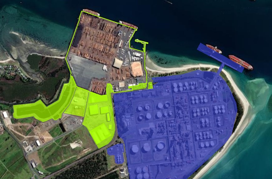
Port profiles identify:
- a port’s securely fenced area (the boundary), shown as a green line
- buildings, installations, other structures, or equipment adjacent to the port and used in connection with the port’s operation or administration, shown as a green polygon
- major hazard facilities (MHFs), to show where Maritime NZ and WorkSafe designations apply, shown as a blue polygon.
The designation also applies to the following areas.
Private roads
Roadways entering a port’s fenced area, where they are privately owned and part of the port’s traffic management plan, are in scope of the designation.
On the maps, these roads are shown in the same way as adjacent buildings used for port operations, as a green polygon.
Moving plant, vehicles, and rail
Moving plant, transport operators, people, and moving rail are included in the designation while they are within the scope of a major port.
Pipework
Pipework on major ports can fall under different regulations. Pipework can cross boundaries and connect sites outside a major port to ships by passing through a major port.
Unless otherwise required by the particulars listed below, when pipework on a major port is not part of an MHF, Maritime NZ is responsible for regulating that pipework.
When determining responsibilities, consider:
- whether the pipework meets the definition of a pipeline under the Pipeline Regulations
- the associated storage containers, for example whether any pipework meets the definition of a major hazard facility under the MHF Regulations
- the site itself, for example the PCBU and the boundaries of the relevant major port.
Ports covered by the maps (north to south)
North Island
- Northport
- Ports of Auckland
- Port of Tauranga
- Eastland Port
- Napier Port
- Port Taranaki
- CentrePort Wellington
South Island
- Port Marlborough
- Port Nelson
- Lyttelton Port
- PrimePort Timaru
- Port Otago
- South Port